Kite mapping
This is something I’ve been meaning to try for myself in some of the ruined iron-age villages up on the moors in Cornwall and Devon one summer. Richard Hayler and his son learned about kite mapping at last year’s EMF festival, where the younger Hayler won the workshop competition. The prize? Two kite kits.

Richard had noticed that most kite mapping projects use cheap, second-hand consumer cameras from eBay; if the camera has a continuous shoot mode, and a bit of cardboard could be wedged over the shutter button, it’s useable. But Richard realised:
However, even a second-hand camera could set you back £30 or so – comparable to the cost of a Raspberry Pi A+ and camera. I’d been thinking about a Pi-based kite-mapper over the winter and when I saw that AverageManVsRaspberryPi had released a new version of the excellent ProtoCam board for the A/B+, I decided to see what we could put together.
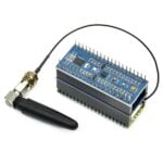
Why use a Pi and camera board? You get tons of extra functionality. The Haylers could calculate how high the kite was flying, add some image stabilisation, and ensure the Pi was only taking pictures when the camera was pointing straight down (essential in blustery weather). It gives them the potential to add GPS logging to the pictures, and much more. Alongside the ProtoCam (we love these little boards – they’re a prototyping board that you can slot your Pi camera into, and are brilliant for adding buttons, leds, displays or whatever else you want to the camera), they bought a Freescale Xtrinsic Sensor Board, which incorporates an altimeter, an accelerometer and a magnetometer, and can be plugged straight on to the Pi’s GPIO pins.

Stacked together, the whole payload looks like this:

Richard walks you through the build and through the tests they ran over at his blog; since then, he’s also run some more test flights and has refined the hardware with a case and some other tweaks. The results are joyous.


This is a terrific project for schools to get into: in an environment where cross-curricular resources are increasingly important, kite mapping is something that can roll history, geography and, of course, computing up with physics and maths. Not bad for a day out with a kite.


11 comments
Yvan T.
OH cool,
So on top of having Google maps we will soon have PI maps :)
Marc
Switch from google maps to OpenStreetMaps, photos are very usefull to contribute.
Marc
Alan Mc
Mary Poppins would be proud! (& now I’ve an earworm… ♫ Let’s go fly a …♫) Excellent project.
Hove
Thanks for making your earworm viral “up to the highest height” :-)
Helen Lynn
On the subject of camera orientation in aerial photography, I recently came across the very interesting use by Francois Dion and the PYthon Piedmont Triad User Group of a modified Picavet rig to stabilise a payload incorporating a number of camera modules for a HAB launch. But Pierre Picavet designed his entirely mechanical rig, dating back at least to 1912, for kite photography, and it’s well within the reach of hobbyists.
Average Man
Oh wow that’s a mega project! Love seeing my little board idea being put to such brilliant use!
Nice work Richard & son :)
Steve Foster
Stroke of genius to only trigger the shutter when pointing down. This is an excellent project. Thanks for sharing Liz.
Kevin Hainsworth
If my memory serves me correctly in the UK a tethered kite is not as restricted in its use as a Drone with a camera is. For a flavour of what can be achieved have a look at what this guy produces, though not using a Raspberry pi he knows all about KAP. http://www.flickr.com/photos/bblakecambridge/
D.S.Matthews
Try using Hugin – Panorama photo stitcher to get better results in the final composite image.
It also does HDR stacking if you can bracket your images for each view before merging the results.
zugProg
wow! The quality is much higher!
Congratulations!
HJODH
search for “KAPWA” (kite aerial photography world association). The first kite-photo (plate camera!) was made more than 100 years ago. Since then many people have developed kites, rigs, remote controls etc. etc.
And fly kites, it’s fun and some experience with it will improve the images.
Comments are closed