Taking care of urban nature with Raspberry Pi
A team from the Electrical and Computer Engineering department and the Forestry faculty at the University of British Columbia has designed a system that combines data from multiple sensors to protect and manage nature in cities.
This system can not only identify, monitor, and assess the value of natural assets – trees, for example – in cities, but can also generate actionable insights about how natural assets are used by people. For example, if people congregate around trees in an otherwise unshaded area on hot, sunny days, town planners could consider whether to plant more trees, or provide seating or rubbish bins near existing ones.
Three-part system
The UBC team’s solution measures soil and tree health, as well as human behaviour, using three different data sets.

Ground-based sensors (1) installed in trees and the soil of the tree base monitor ecological activity. Meanwhile, aerial sensors (2) mounted on an unmanned aerial vehicle, together with mobile data (3) taken from smartphones, monitor both ecological and social activity.
Tree and soil sensors
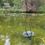
Soil sensors measure soil conditions, while the accelerometer sensors in the trees measure how they move in the wind.
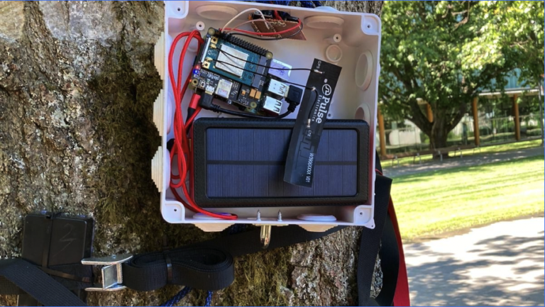

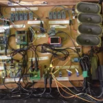
Power supply and data logging hardware for both soil and tree sensors live inside plastic enclosures: the data logger is a Raspberry Pi. Each Raspberry Pi is connected to a cellular module for communication, and both Pi and module are powered by the same power bank that serves the sensors. Soil sensors live two feet underground, with the enclosure full of other hardware sitting just flush with the surface, while the tree sensors sit up on branches, with the enclosure mounted on the trunk.

Each Raspberry Pi collects data every 60 seconds and uploads it to InfluxDB and Azure. A big Grafana dashboard displays everything all together.
The team manually soldered 60 sensors into nine sensing devices. Rather them than me. My soldering is terrible.
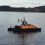
Unmanned aerial vehicle sensors

A multispectral sensor mounted to an unmanned aerial vehicle (UAV) detects and records changes in colour in tree leaves. Using a UAV means the team can record over a huge area much more quickly than if they had to do this themselves on foot.
Mobile phone data
Mobile phone data helps understand how human behaviour affects the condition of urban trees. From this, you can infer how people use natural assets, and how valuable these are to a city population. If city planners were wondering whether it was worth investing in lots of green spaces, the team’s data could show them just how many people use them. The data can also tell you how much trees and vegetation deteriorate based on footfall compacting the ground around them, so planners can set appropriate budgets for taking care of them.

1 comment
AndrewS
Do the accelerometers on the tree branches also monitor if people are climbing the trees? ;-)
Comments are closed