CanSat: A tiny, can-sized, Raspberry Pi-powered satellite
A competition for space-bound students resulted in a tiny, can-sized, Raspberry Pi-powered satellite. Rob Zwetsloot boldly takes a look at it.
What would you do if you had to create a satellite the size of a drinks can? The yearly CanSat competition for students in their teens asks this question, and many teams have answered — including LittleBlueDot.

“The challenge for students is to fit all the major subsystems found in a satellite, such as power, sensors, and a communication system, into this minimal volume,” the team tell us. They came third in the country for their final build. As the competition instructions explain, “After building their CanSat, teams will be invited to launch events across the UK to launch their CanSats on small rockets, with their CanSats returning to Earth using a parachute designed by the students. Teams are set a primary mission of measuring air pressure and air temperature during the CanSat’s descent, with data being transmitted to the students’ ground station.”
They also needed to design a secondary mission, which in the case of LittleBlueDot included taking photos of the ground below to map it. “The idea of mapping large areas, including foreign bodies, came up when we were discussing potential asteroid mining in the future,” the team say. “And also improving efficiency in agriculture, both fields where large benefits could be seen from mapping land cheaply.”
Trial and error
For the project, Raspberry Pi was an obvious choice for the team — while a microcontroller would be able to handle the environmental recording and transmitting requirements, a Raspberry Pi computer allowed for on-board image processing. The team then got to work building and refining.

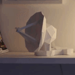
“Initially, a very basic CanSat was made to help visualise the size and space that was available to be worked with,” they explain. “Different ways to secure the Can’s inner electronics in an accessible way were explored. In V0, there were two bodies: a screw lid with an attached compartment behind, and the main module itself.”
The V1 build went from a vertical orientation to horizontal to accommodate a larger gap between the cameras. Across V1 and V2 builds, different ways of wiring up and loading the circuit were explored, and clear acrylic discs were added to protect the cameras from moisture and reduce their drag.
“In V1, the parachute was attached via four straight vertical holes,” the team continue. “V2 featured a more reliable solution, using four M5 nuts inset into the walls of the Can to secure the paracord in place and put the strain on the parachute rather than on the Can itself.”

After some issues at the regional launch, a V3 was created to better fit all the components they required.
“The Can was simplified by removing the inner module and trays [for the electronics], and a friction fit was used to directly mount components to the inside of the CanSat,” the team say. “During testing of the temperature readings, it was found that heat from the internal components was affecting the readings being taken. To mitigate this, fans were added for cooling, and vents were installed on both sides of the CanSat using a honeycomb grid to allow air flow. The strength of the vents were tested in Fusion 360 and they still passed the stress tests.”
With this, they were ready for the national launch, where they were part of the national finals.
Mapping with data
As well as cameras, the CanSat had temperature and pressure sensors, an IMU (inertial measurement unit), a magnetometer, and GPS. These were used to calculate altitude and orientation.

“The two on-board cameras took photos of the ground simultaneously,” the team explain. “This meant that an FFT [fast Fourier transform] taken of an image from the first camera would give a wave that was a translation of the wave an FFT would give for the second camera. This translation would vary based on the orientation of the Can, the distance between the two cameras, the altitude of the Can, and finally the actual altitude of points on the ground. Given values for the first three variables, the fourth could be calculated using trigonometry.”
The team came third overall in the competition. And the data? Sadly, due to a safety quick-release switch being released during launch, they were only able to get one set of images. Hopefully they can get it all working for another launch.


7 comments
WARREN ALLEN EVANS
Very proud of these guys! Keep going and don’t let up!
Person in Louisiana, USA
Arca Cengiz
Congrats on making it to the Raspberry Pi website! If you’re reading this, I’m the electronics guy from Team Athena, I remember meeting you all in the finals in York. The article missed it but your motorised dish antenna was an absolutely brilliant marvel of over-engineering :)
Arca Cengiz
Also forgot to add: @raspberrypi if you’d like details on our CanSat, you can contact me with the e-mail I used to post this, but here’s a quick summary if you’re interested:
Our secondary mission was to measure the suitability of a location for wind power production and we integrated an anemometer into the design (using magnets and hall effect sensors to measure rotation of the cups). Due to the anemometer, we had to design uprighting legs to make the CanSat landed upright (which it surprisingly did; I remember being told we were told we were one of the first teams ever to do so).
Instead of using a full Raspberry Pi, we used an RP2040-based microcontroller, the Pimoroni Pico LiPo, since it uses much less power and we weren’t doing anything that required a normal Pi. I was the team member who did the electronics design and wrote the majority of the code that ran onboard the CanSat. We used FreeRTOS on the Pico (because why not?) and I implemented the LittleFS filesystem on the 16MB flash of the Pico LiPo to save readings onboard in case we lost signal (which did end up happening during the launch because our ground antenna disconnected 😬).
We decided to open source everything after the end of the competition, so here are all of our repositories: https://github.com/orgs/CanSat-Athena/repositories
Helen McCall
This competition looks like a lot of fun. Is there a category for teams of OAPs?
Steen Christensen
As a fan of in many years. is your projekt interesting for me. i have myself build a pico w with temp. and humanity.
best regards Steen
hosein
This is an amazing project! The level of engineering and problem-solving involved in designing such a compact yet functional satellite is truly impressive. Using Raspberry Pi for onboard image processing was a great choice, and the iterative design approach clearly paid off. Even though there were challenges during launch, coming third in the competition is a fantastic achievement. Looking forward to seeing how the project evolves in future launches!
Ben Jarvis
Great article, well done to your team and all the others who have enetered the competition the last few years! We (Launch Access) have now provided launch services to carry nearly 400 CanSats into the sky onboard our rockets, becoming global experts in CanSat (and educational) launch in the process. We’d love to expand our work and expand the reach of the CanSat concept too. Would love to speak to anyone interested in getting involved or working with us!
Comments are closed